
This is an excerpt of Palestine 1492: A Report Back, by Linda Quiquivix
Maps arise when societies call for them. Those who know the land intimately don’t need maps, at least not ones on paper. Before the idea of a State of Palestine was born, Palestinians didn’t make statist maps. Nobody did until a couple hundred years ago with the invention of the nation-state.[1]
Every Palestinian geographer I met in Palestine confirmed that the first maps Yasser Arafat signed in the Oslo peace process were Israel’s maps. In the disaster that was the peace process from above, Palestinians didn’t have their own maps.
Today, Palestinians make a lot of maps and operate their own geography institutions, and still they don’t have a state. That Palestinians did not have their own maps is not why they have been displaced. Still, the Palestinian leadership insists that mapping a border between the State of Israel and a State of Palestine will solve everything: a two-state solution. It’s not clear if the leadership can admit that the border between Israel/Palestine already exists and it’s not a line on the map. The Israel/Palestine border is the line between Peace/War of empire; the line between Europe/non-Europe of colonialism; the architecture of Above/Below of apartheid; the split between Human/non-Human of cannibalism.
None of this is to say the map is useless or should immediately be discarded. As Edward Said put it:
In the history of colonial invasion maps are always first drawn by the victors, since maps are instruments of conquest. Geography is therefore the art of war but can also be the art of resistance if there is a counter-map and a counter-strategy.[2]
The borders of Historic Palestine are colonial constructions, but Palestinians have long counter-mapped that construction against the colonizer. Maps of Palestine in necklaces, embroidery, and other artwork have helped build a consciousness of a common struggle among everybody within the colonial outlines of that map. Palestinian communities are highly diverse, yet every single one whose lands are within the colonial borders have been marked for extermination. The counter-map of Palestine convokes their collective resistance.
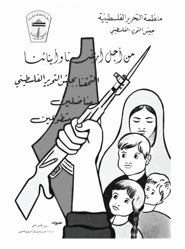
In this popular political poster published by the Palestine Liberation Organization (PLO) in 1964, the map of Palestine appears prominently in the background and is accompanied in the foreground by Palestinian children, a Palestinian woman, and imagery of armed struggle.
The poster reads,
Palestine Liberation Organization-Palestine Liberation Army. For the sake of our land and our children we joined the Palestine Liberation Army as fighters and volunteers.
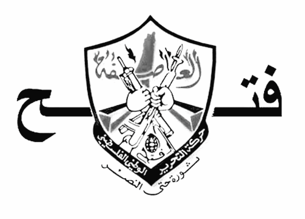
The Fatah emblem above on the official party flag features the map of Palestine behind two AK-47s and a grenade. The text reads Fatah: the National Liberation Movement of Palestine. Revolution until victory.
The emblem below of the Palestine Front for the Liberation of Palestine (PFLP) has the map accompanied by the Arabic letter jim from the word Jibha, or “Front,” which takes the form of an arrow into Palestine, symbolizing its insistence on the refugees’ return.

The Hamas emblem shows the map of Palestine above the al-Aqsa Mosque compound’s Dome of the Rock where two swords cross in front. The Dome is framed by two Palestinian flags with the statements that comprise the Shahada: There is no god but God on the right flag, and on the left, Muhammad is the messenger of Allah.

Al-Aqsa regularly appears in Palestinian imagery to symbolize the sacredness of Jerusalem, difficult to communicate in modern cartography, whose tendency is to reduce the Holy City to a mere point on the map.
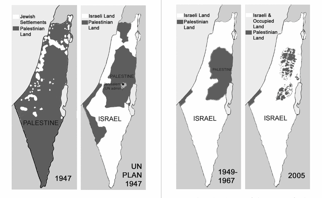
This four-panel map powerfully communicates Israel’s ongoing destruction of Palestine. It circulates widely in Palestine awareness campaigns. It doesn’t show the Occupied Golan Heights or the presence of Palestinian Citizens of Israel. It takes aim at Israel’s growing settlement activity in the West Bank and deliberate sabotage of a two-state solution.
Although Palestinians did not make many scientific maps before Oslo, ten years before Oslo in 1983, a Palestinian team of surveyors from the Jerusalem-based Arab Studies Society began mapping Palestine, highlighting Palestinian towns and villages and Jewish settlements as they existed on the eve of the Nakba.
The map below was published in 1988 five years after fieldwork first began and would become the first full map of Palestine made by Palestinians. This is according to Palestinian cartographer Khalil Tufakji, who had drawn the map by hand from his offices in Jerusalem’s now shut down Orient House, the PLO headquarters in the 1980s and 1990s.
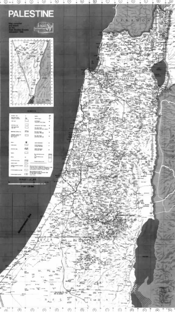
Tufakji gifted me a copy of this map when I visited him for an interview in Jerusalem. I had heard stories of the map throughout the West Bank, that it was everywhere displayed throughout schools and their classrooms. But 1988, the year the map was completed, was also the year the PLO officially adopted the two-state solution as a compromise: a State of Palestine in the West Bank and Gaza Strip next to the State of Israel, the 1949 armistice lines serving as the border.
I asked Tufakji if his maps changed accordingly after 1988, and he confirmed they did. From 1988, as soon as his map of all of Palestine was complete, his future maps would focus only on the West Bank and Gaza Strip, not on Historic Palestine, but on only 22 percent of Palestine.
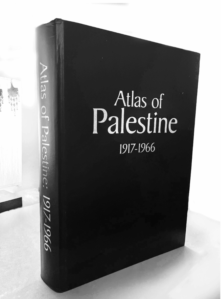
Salman Abu Sitta’s Atlas of Palestine 1917–1966 doesn’t map only the West Bank and Gaza Strip. A large part of the Atlas curates the British Mandate’s Survey of Palestine as Palestinian villages and place names were before the Nakba. Upon the creation of the State of Israel, Israel immediately began erasing Palestinian presence on the British surveys.[3] The Atlas of Palestine counter-maps this erasure.
Abu Sitta’s Atlas also includes analysis of the various colonial partitions, land ownership and population composition before and after the Nakba, the 1949 Armistice Lines, the border with Lebanon, land exchange with Jordan, historical village photos, the destruction of landscape, the dispossession and confiscation of Palestinian property, water and agriculture’s retransformation, and more of Israel’s crimes.
And more than that, Abu Sitta’s work shows that well over 80% of the land is kept empty by Israel, and there is plenty of space for the Palestinian refugees to return.
In 2006 when Google Earth was still new, a Palestinian refugee announced a “grand post” on the Google Earth Community Forum. He had created a map of Palestinian villages destroyed or depopulated in the Nakba to be viewed as a layer on Google Earth. Thameen Darby, a refugee from the village of Balad al-Sheikh, described his “Nakba Layer” as a project that would bring joy to other refugees. Promoting it through mass e-mail, he requested the following message be forwarded widely to interested friends and family:
Do you want to see where your original town or village is in Palestine? If you have Google Earth you can use the attached layer to see the destroyed and existing Palestinian Villages. For those who have not used it yet, Google Earth is a new emerging tool for information exchange based on a three dimensional assimilation of satellite images of the world. Google Earth allows users to add layers to it after they install. There is a layer of all the destroyed Palestinian villages and towns in 1948. This is a big data base that shows the site of each village and directs you to a website that talks about each village in detail.
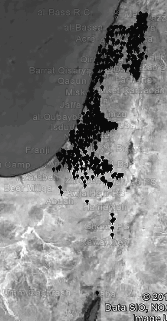
The layer contained location marks for each village classified by district with links to PalestineRemembered.com for more detail. “The issue of these refugees and their right to their native land,” Darby explained on the Google Earth Community Forum, “remains the major obstacle to achieve a long desired peace between the Israelis and Palestinians.”[4]
‘‘How did they know where the borders were?’’ I had asked Palestinian geographer Ahmed Al-Noubani during fieldwork in Palestine. ‘‘If people didn’t have maps, how did they know?’’
Al-Noubani had opened his arm out and pointed in one direction and then another. ‘‘It was that carob tree to that carob tree.’’ Neighbors, he shrugged. They figured it out.
Al-Noubani and I had met in his office at Bir Zeit University’s geography department in January 2011, discussing histories of Palestinian map-making. He had long ago been recruited as part of a Palestinian map-making team at Oslo ‘‘to help us with pull’’ under the framework, he had recounted.
‘‘Land was used for pastures and herders,’’ Al-Noubani continued, recalling a time when maps were rare. ‘‘Tribes knew their borders.’’ Claims to property, he had explained, were made through the Hujja, a land transfer paper agreement where boundaries were not lines but descriptions of natural landmarks that villagers understood between each other.
“But today,’’ he continued, ‘‘the Israeli courts ask, ‘What are the coordinates? What are the borders?’ You can’t say the carob tree is the border. They don’t accept it.’’[5]
Our conversation ended that day with Al-Noubani’s declaration of a wish: that more work be done on the social relations people have with borders. And I couldn’t stop thinking about the tree.
This has been excerpt of Palestine 1492: A Report Back, by Linda Quiquivix
Footnotes
[1] Denis Wood, Rethinking the Power of Maps (The Guilford Press, 2010)
[2] Edward Said, Peace and Its Discontents: Essays on Palestine in the Middle East Peace Process (Vintage, 1996)
[3] See Meron Benvenisti, Sacred Landscape: Buried History of the Holy Land Since 1948 (University of California Press, 2002)
[4] Linda Quiquivix (2014) “Art of War, Art of Resistance: Palestinian Counter-Cartography of Google Earth,” Annals of the Association of American Geographers, 104(3): 444-459
[5] Linda Quiquivix (2013) “When the Carob Tree Was the Border: On Autonomy and Palestinian Practices of Figuring it Out,” Capitalism Nature Socialism, 24(3): 170–189