
This is an excerpt of Palestine 1492: A Report Back, by Linda Quiquivix
Maybe it was after visiting other cities, maybe it was after getting a job on the other side of the city that I started to wonder, Why is Los Angeles like this? Why is Compton Compton? Why is Santa Monica Santa Monica? It was a new growing feeling, that it was alright to ask Why.
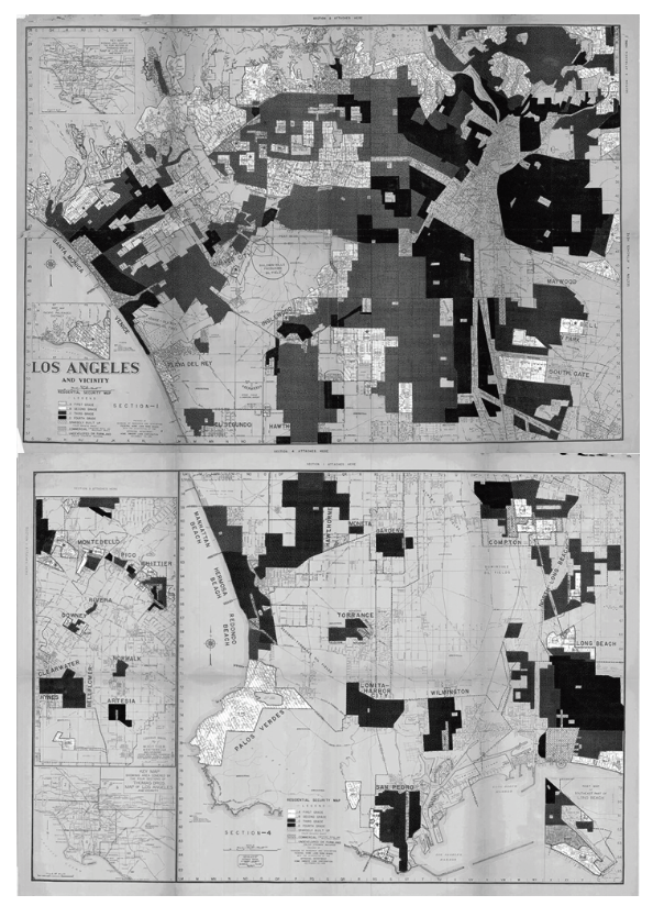
In my final semester before graduation, I enrolled in an Urban Geography course on the other side of campus that helped with an answer. “Residential Security Maps,” or “redlining,” racialized housing discrimination from just a few generations before, systemic in its reach from the politicians in Washington, D.C. to the White neighbors across the street.
Redlining had come out of the New Deal, the economic reforms in the United States during the Great Depression, the first time a Wall Street crash had spread worldwide. The New Deal created jobs for the unemployed and offered Americans a number of socialist programs to help get through tough times.
It does sound nice at first. But the more you learn about the New Deal, the more you remember the struggles of the 1950s, ‘60s, and ‘70s hadn’t happened yet. Redlining was one of the New Deal’s lasting discriminatory legacies still physically present on the landscape today. It was part of a financial aid package to help White people realistically purchase a home through mortgages, by making smaller payments over a longer period of time, denying the same for non-White people, especially denying the same for Black people. The New Deal was legal economic warfare, a shift in American strategy after blatant plantation warfare became illegal.
Compton had originally been a White colony of Los Angeles called Comptonville in the 1860s, named after an American settler who had led a group of some 30 others to Occupied Tongva lands near Paayme Paxaayt, the West River, today’s Los Angeles River, the place that used to be the Tongva peoples’ main source of food. By the time Compton and Them arrived, the river had long been seized as private property by the Spanish Empire before it was taken by the Mexican Empire and then taken by the American Empire, along with the Pueblo de los Ángeles.
The Americans kept Los Angeles’ name in Spanish, shortened from the much longer El Pueblo de Nuestra Señora la Reina de los Ángeles del Río de Porciúncula, The Town of Our Lady the Queen of the Angels of the River of the Porciuncúla, first named this way by the Spanish Empire who first seized the land in 1781 and founded the town through enslaved Tongva labor and the destruction of Tovaangar, the Tongva world. To accommodate Los Angeles’ growth, the river was channeled with concrete so it would stop moving location and not take up so much real estate.
On the redlining map of Los Angeles 70 years after Compton and Them, a chunk of West Compton was colored in Red. Compton was still largely White at the time of redlining, but that Red area on the map was described as an old blighted laborers district with serious subversive racial influences and threats. Specifically, the map warned of a Threat of negro infiltration from areas north, “areas north” meaning Watts and South Central, both geographies labeled Negro: 50%, also colored in Red.
Some 70 years before, at around the time of Compton and Them, enslaved Black people in the U.S. South had just forced the abolition of slavery in the United States. It happened during the Civil War, which ended in 1865 between White people but still hasn’t ended against Black people.[1] Many Black people the South fled to Los Angeles for safety but were met with economic and legal warfare.
After the Civil War, the U.S. Constitution had been amended to abolish slavery, but still allowed the enslavement of anyone labeled a criminal. Since then, the United States has been labeling Black people criminals. They say Black people are only 14% of the population in the United States, yet of the incarcerated population in the United States, Black people make up 37%. Black people are only 14% of the population in the United States, yet of those serving life sentences in the United States, Black make up 48%. Los Angeles incarcerates more people than any city in the United States.[2]
Plantation slavery may have legally ended in the United States, but its notions of freedom and slavery keep the White/Black binary mapped onto the Master/Slave relationship, a war that has not ended in the United States.[3] Subjected to continued White-supremacist terror through law, police violence, and paramilitary violence often by those same police, between the 1910s–1970, millions of Black people fled the South for safety and for work in cities like Chicago, Detroit, New York, Oakland, and Los Angeles.
The color Red on redlining maps translated to mean Hazardous, the worst of the map’s four possible colors, geographies that would be readily denied mortgages and insurance.[4] Another chunk of East Compton was Blue, the second-best label, Still Desirable, places of good character where the Professional and business people, skilled artisans, Jr. officials, etc. lived and with Negro: 0% and Nationalities: None subversive.
Green was labeled the Best of the four possibilities. In Los Angeles, these geographies were places where Executives, retired capitalists, and movie people, etc. lived. Still live. Beverly Hills was colored Green with Foreign Families: 0%; Negro: 0%; and with sometimes only a Slight infiltration of Jewish people. The year of the map had been 1939, the year Hitler invaded Poland.
Foreign Families: 30%; Nationalities: Mexicans, the Red chunk of Compton warned in 1939. Negro: Few %. Directly south was colored Yellow, not Red. Yellow was the second-worst on redlining maps, labeled Definitely Declining but not Hazardous like Red. Class and Occupation: Professional and small business men, white collar workers, etc; Foreign Families: Few %; Nationalities Possibly few Mexicans; Negro: None % but considered to be Definitely Declining because Threat of subversive racial elements from north.
Santa Monica is a beach-front settlement that maintains its name from the time of the Spanish Empire, the time of the first European settlers in Tovaangar, the time of the ones who first imposed their world on top of other worlds. The Tongva village of Comicranga was destroyed to create Santa Monica. They say the daughter of the village chief had his daughter kidnapped at the age of six by the colonizers, who sent her to their concentration camp euphemistically called the San Gabriel Mission so she could stop being Tongva and could instead become property.
At the time of the redlining maps, about half of Santa Monica was Red. This surprised me. I was working in Santa Monica at the time and knew it as a very expensive, very White part of Los Angeles. Back in 1939, the map said the Red-colored part of Santa Monica had been Negro: 10%. I didn’t know that many Black people had once lived in Santa Monica. They had been domestic workers and janitors for the ones who lived on the other side of Montana Avenue, near the Brentwood Country Club, colored on the map Blue, a place offering many marine and mountain view Homesites and proximity to the beaches. This blue area was the “sundown” part of Santa Monica where Black people weren’t allowed to be after sundown. A freeway was there now, the Red part of Santa Monica where Black people had previously lived.
Maybe the professor noticed me become indignant at this history. When he learned I was good at computers, he said I could change the world by making maps. He meant Geographic Information Systems (GIS) and encouraged me to enroll in the Geography Master’s program and begin next semester. I applied and was immediately rejected. My grades during undergrad had sometimes been the lowest in the class, sometimes the highest in the class, depending on the subject and the professor. I barely averaged a C. I successfully appealed my rejection and promised I would do well, which ended up being true. I would graduate the Geography Master’s program with honorable distinction, straight As. My thesis would receive a major award, encouraging me to enroll next in a doctorate, also in geography.
I had begun the Master’s program in August 2003, and in addition to learning GIS and mapping Los Angeles’ freeway pollution and the city’s Guatemalan neighborhoods, I also learned geography was about critical thinking on migrations, borders, culture, placemaking, and globalization. “Critical” meaning asking all the Why questions, examining the unspoken assumptions. It was different from business school, where I had learned mostly the How-tos, not very much of Whys.
In a geography seminar entitled Globalization was where I first learned to think critically about capitalism. It was also where I first learned about the Zapatistas and kept seeing the phrase Free Palestine. It was the movements themselves who had made the distinction between globalization from above and globalization from below, Above and Below were simply another way to reference the familiar split between “the Haves and the Have-Nots,” as everyday people often say. The Zapatistas were credited with launching the globalization from below “movement of movements” with their uprising on January 1, 1994, weaving solidarity across the globe, making clear they were not anti-globalization but were for a different type of globalization, an alter-globalization, “a world where many worlds fit,” as the Zapatistas were saying then, “a world where all the worlds fit,” as the Zapatistas are more precise in saying today.
In that Globalization seminar is when I first saw the name Karl Marx appear in any book I was holding in my hands. The first time it happened I froze, but the professor and the rest of the class just kept going. We were reading Empire, a then-recently published academic book that had sold a lot of copies, rare for any academic book.[5] The professor had assigned it because everybody was reading it and so we had to know about it. Few of us understood it, but the little I grasped blew my mind, as they say. It felt everywhere I was looking, I was seeing empire. Or maybe I had already been seeing it, and just needed the concepts. It felt everywhere I was looking, I was now more and more asking Why.
A flood of questions beginning with Why began to flow on things I hadn’t been allowed to question as a Democrat. It felt liberating to shake off the binary Democrat vs. Republican. It was becoming clear all agreed on war and worked to preserve empire, the corporate globalization of death and destruction. I was understanding more now, but I was no longer aligning with most people around me.
Like there exists a globalization from below, there also exists a transnationalism from below. “Transnational” is not only for corporations. Migrants were also transnational, interconnected across borders, not reducible to a single nation. Just like my family. Border transgressors, not reducible to any single nation. I smiled at learning this and wrote my thesis on the topic, on what Guatemalan transnationalism looked like between Los Angeles and Guatemala. For the first time I got to visit Guatemala, and for the first time, I got to learn what it felt like to have a parent help with your homework. My own mother was an expert, a transnational migrant before the academics had even invented the phrase.
In a seminar called Geographic Thought was where I first encountered the name Edward Said (pronounced Sa-eed). It was September 2003. He had just been killed by cancer, a Lebanese classmate shared with the class. The professor bowed his head. The late Palestinian intellectual Edward Said had not been a geographer, but his critique of Orientalism, the West’s geographic imaginations about the East, about Asia, exists as part of the Human Geography critical theory canon, that is, a lot of geographers have built from Edward Said’s critique of Orientalism.[6]
Edward Said, presente.
When I first learned about Edward Said he had just died, and Israel had just begun construction on the Apartheid Wall, describing it as a security barrier between Israel and the West Bank. Israel’s own maps showed the Wall deviating far away from its supposed border, encroaching into the West Bank to take more land from Palestinians, confirming my suspicions about walls and borders everywhere being violent and unnatural, confirming my suspicions about Israel.
This has been excerpt of Palestine 1492: A Report Back, by Linda Quiquivix
Footnotes
[1] W.E.B. DuBois, Black Reconstruction in America: An Essay Toward a History of the Part Which Black Folk Played in the Attempt to Reconstruct Democracy in America, 1860–1880 (Harcourt Brace & Company, 1935)
[2] Kelly Lytle Hernández, City of Inmates: Conquest, Rebellion, and the Rise of Human Caging in Los Angeles, 1771–1965 (UNC Press, 2017)
[3] Edmund Morgan, American Slavery, American Freedom: The Ordeal of Colonial Virginia (W. W. Norton & Co Inc, 1975)
[4] Digitized redlining maps of various cities across the United States are freely accessible to view and download online at the Mapping Inequality: Redlining in New Deal America project, put together by Robert K. Nelson, LaDale Winling, et al (2023) https://dsl.richmond.edu/panorama/redlining
[5] Michael Hardt and Antonio Negri, Empire (Harvard University Press, 2000)
[6] Edward Said, Orientalism (Pantheon Books, 1978)