
This is an excerpt of Palestine 1492: A Report Back, by Linda Quiquivix
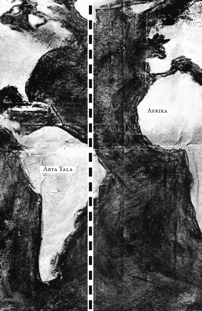
In 1493 Columbus and Them returned to Europe from their first pillage in Abya Yala, landing in Portugal first instead of Castile. The King of Portugal was the first Catholic Monarch to hear the news. When Isabella learned Columbus failed to inform her first, a fight ensued between the Catholic Monarchs over who had the right to invade the new lands. To keep the peace, the Bishop of Rome stepped in.
The Pope, the Bishop of Rome, issued a Doctrine of Discovery proclaiming the right of Christians who “discovered” the lands of non-Christians to take the lands as property. To keep the peace between invaders, the Pope cut the world in two with a line dividing the globe between Portugal and Castile. It was the first global border, a line between the invaders so they don’t fight each other and can keep fighting everybody else.
The primary global border assumed that day was not the line for peace but the line between Same/Different, between Superior/Inferior, between Christian/non-Christian, Europe/non-Europe, Human/non-Human. Today, the Christian/non-Christian split is less spoken out loud but remains in practice. As decolonization institutionalized in the twentieth century, the Europe/non-Europe split became less explicit but also today remains in practice. The Human/non-Human split remains openly explicit and in practice, paradoxically strengthened by the institutionalization of Human Rights.
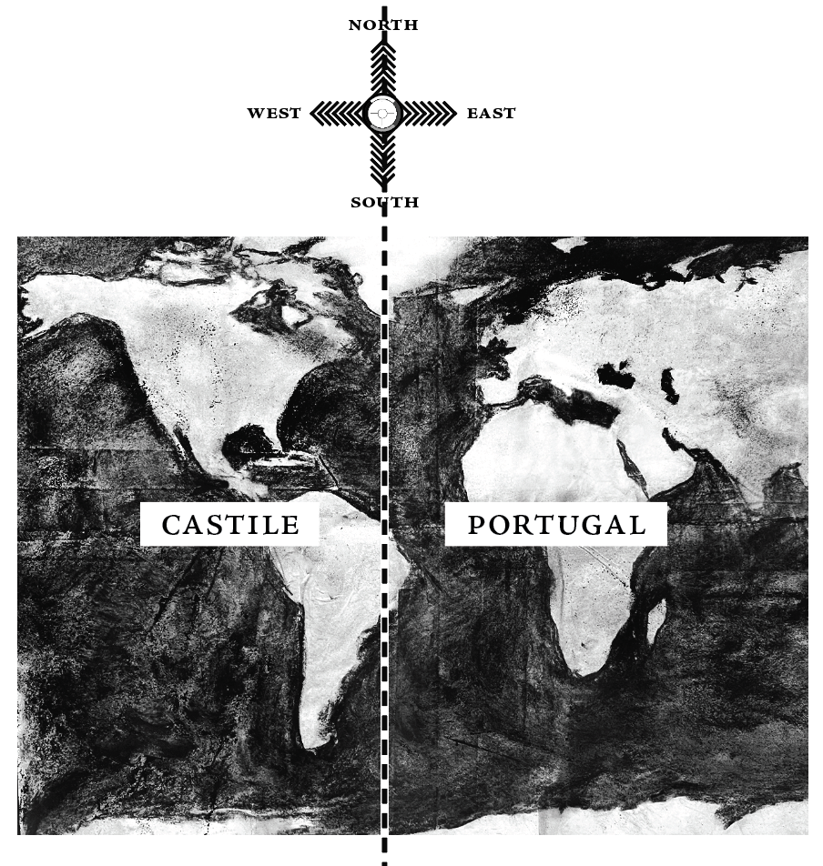
Following the Doctrine of Discovery, the Bishop of Rome’s Treaty of Tordesillas in 1494 cut a line from North to South at the Atlantic, right at portion of Abya Yala today called Brazil.
The Portuguese Empire was granted by Rome the right to invade everything east of the line, including all of Afrika. Castile was granted everything west.
The Doctrine of Discovery became the basis of all claims to non-Europe by Christian Europeans, including by the United States who pointed to it in 1823 as the legal foundation for its westward expansion. It remains on the law books today.
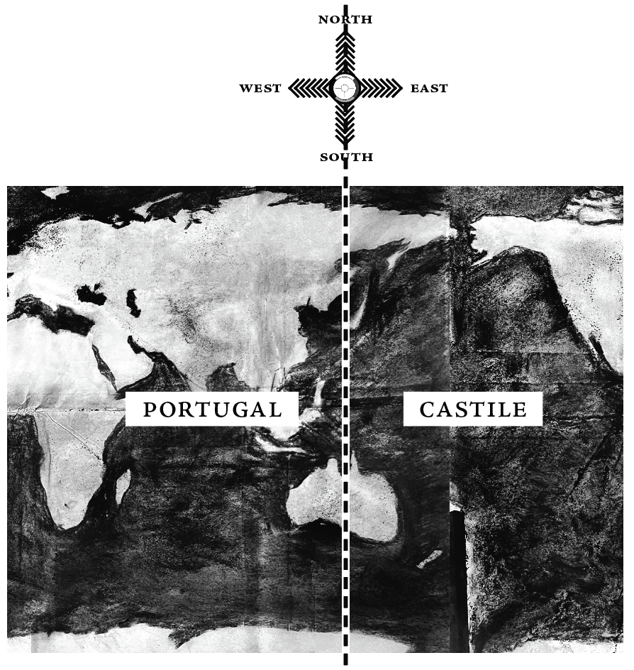
In 1521, Portuguese explorer Ferdinand Magellan sailed west of Abya Yala and landed in Asia on an island archipelago where he would be killed by the native people in an uprising.
On this other side of the globe, where the east could indeed be reached by sailing west, invasion rights between the Europeans were still unclear. In 1529, Portugal and Castile signed the Treaty of Zaragoza in order to keep their peace. Still, the Spanish would later transgress the line and colonize the islands where Magellan died, naming them the Philippines after a Spanish King named Philip.
Those who followed Columbus and Them to Abya Yala continued cutting up the land into borders between them as plantations called Viceroyalties. These lines eventually informed the footprints of today’s nation-state borders, agreements between the overseers so they don’t fight.

Abya Yala was not consulted.
The establishment of clear lines between European invaders in Abya Yala and a clear distinction between Europe/non-Europe were foundational to International Law, originally designed to produce Europe as the place of lawfulness, even under conditions of war, and non-Europe as the place of lawlessness and under conditions of perpetual war.
Following the global decolonization movements and the implosion of Europe after the Second World War, Europe created the United Nations and adopted a new doctrine of a Universal Human Equality. It de-emphasized the split between Europe/non-Europe and instead emphasized the split between Human/non-Human, different words for the logic and practice of Superior/Inferior, of Haves/Have-Nots. The United Nations has since granted the overseers the legitimacy on the monopoly of violence and has labeled as “terrorists” those who disagree.
Lamenting the the doctrine of Universal Human Equality, a Nazi philosopher argued that with the dissolution of Europe/non-Europe, the neat geography between Peace/War was also dissolved, meaning violence between Europeans could not easily be exported to non-Europe, transforming Europe back into a space of perpetual war and all of the globe into a space of perpetual war.[1]
Previously in 1618, with Europe out warring with non-Europe outside of Europe, a bloody 30-year war had erupted inside Europe’s so-called Holy Roman Empire, a regime many argued even was neither holy, Roman, nor an empire.
As the favorite ancestor of today’s State of Germany, the Holy Roman Empire had been baptized that way by the Bishop of Rome in the year 800 A.D. He had been seeking to revive the title in Western Europe more than three centuries after the fall of the Western Roman Empire in 476 A.D.
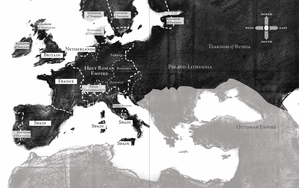
The 1648 Peace of Westphalia ended the 30-Year War and established a secular order. This set in motion the internal cutting up of Europe into borders so its tyrants wouldn’t fight each other inside of Europe. The lines didn’t look as neat as they do even on this map. For a long time, this “colonial reflection” of bordered territory inside Europe remained administered through lists of place names; not until much later did it reference scientific maps.[2]
The so-called Holy Roman Empire continued its decline until Napoleon fully destroyed it in 1806. In 1871 it resurrected as the nation-state of Germany, the Second Reich to the Nazis’ future Third Reich.
During the Second Reich, during the so-called “unification” of Germany in 1871, difference within Germany’s borders was annihilated in the name of unity, in the name of creating a nation-state. The Third Reich would later seek to annihilate difference within all of Europe, also in the name of unity.
The Second Reich had been a late comer to the imperial conquests of its European peers. Wishing to join, the new State of Germany hosted the Berlin Conference between 1884–1886 to peacefully cut up Afrika between it the other European powers, placing a map of Afrika on the wall.
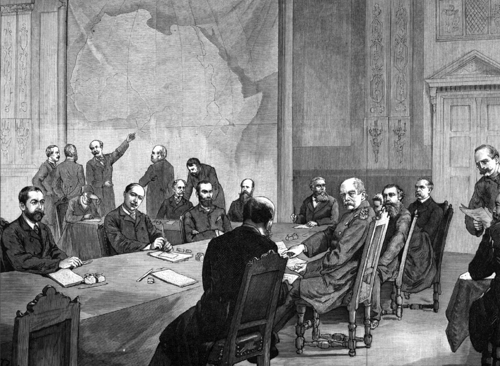
Also known as the Congo Conference, the border around the Congo River was decided and granted to King Leopold II of Belgium as his personal property.
The Congo River was not consulted.
The “Scramble for Africa,” as the Europeans called it, continued until 1914. Throughout this time, the invaders refined the rules between them to reduce the possibility of conflict erupting among them. It was during this decades-long process when Europe’s Zionist movement tried negotiating for a Jewish State in East Afrika before it settled on a Jewish State in Palestine.
As in Abya Yala and as in Europe before it, the lines the Europeans cut over Afrika eventually informed the footprints of today’s nation-state borders and are central to the story of the genocides in Afrika that have not ceased to this day.
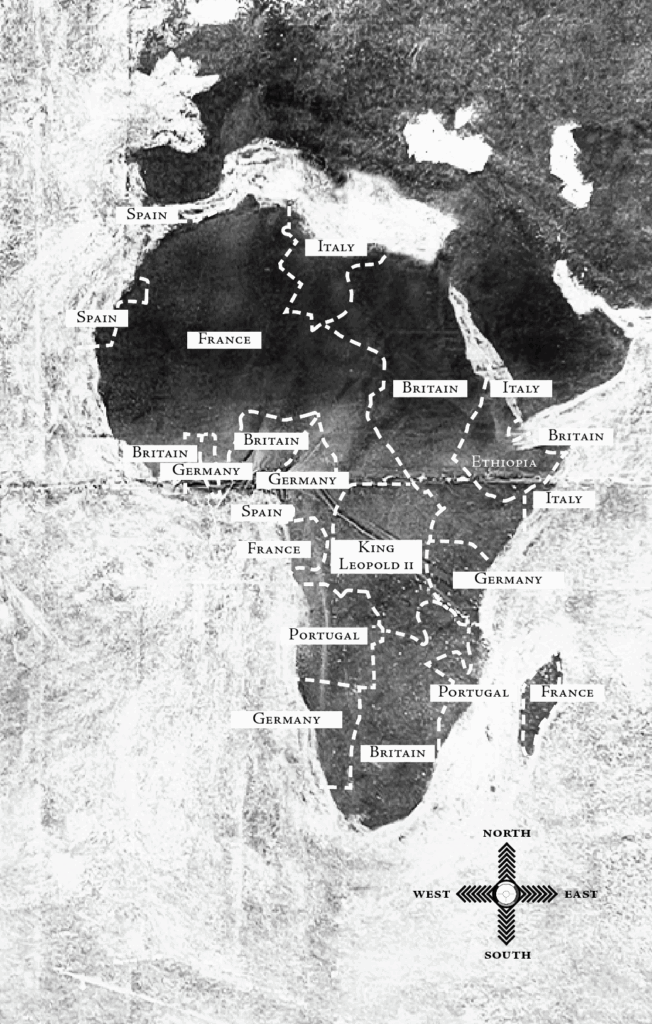
Neither Afrika nor its people nor its waters nor its trees were consulted in the political process. As in Abya Yala and as in Europe before it, the borders of Afrika were and continue to be peace agreements between the overseers, between the administrators above so they don’t fight each other and can instead focus on fighting everybody else.
With the cutting up of Afrika about complete, in 1916 the Europeans began cutting up the Eastern Mediterranean while fighting the Ottoman Empire. This happened during the so-called First World War, the first world war between Europeans, whose wars in non-Europe were boomeranging back into Europe.
While making promises of freedom from the Ottoman Empire to the communities on the ground, the Europeans secretly drew a map with borders between them so they wouldn’t fight each other after the Ottoman Empire’s collapse. The following year, the regime in Russia was overthrown and the rebels leaked the secretive European agreement, “Sykes-Picot”and its map.
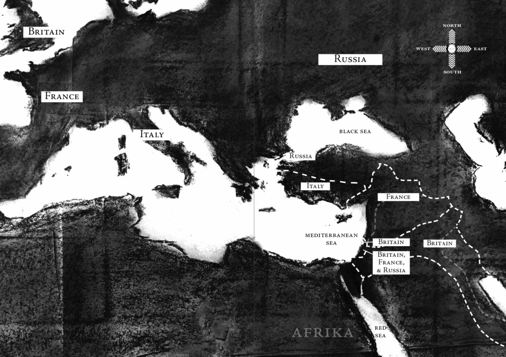
The Sykes-Picot borders between European invaders eventually informed the footprints of today’s nation-states, including Turkey, Syria, Lebanon, Palestine, Jordan, and Iraq.
Neither the land nor its people nor its waters nor its trees were consulted.
This has been excerpt of Palestine 1492: A Report Back, by Linda Quiquivix
Footnotes
[1] Carl Schmitt, The Nomos of the Earth in the International Law of Jus Publicum Europaeum (Telos Press Publishing, 2006)
[2] Jordan Branch, “‘Colonial reflection’ and territoriality: The peripheral origins of sovereign statehood,” European Journal of International Relations 18(2): 277–297